Point Clouds
Point clouds have the following properties:
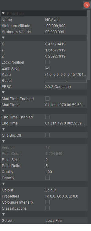
- Name:
- Can be changed by clicking and typing over.
- Minimum/Maximum Altitude:
- Set constants for the data object.
- X,Y,Z:
- Current local position, can be changed by clicking and typing over.
- Lock Position:
- Locks the object that stops you from accidentally moving the Data Object on the screen.
- Earth Aligned:
- Will rotate the objects up axis to the globe up axis.
- EPSG:
- Moves the point cloud to the georeferenced position if not done so at VPC Creator time.
- Version:
- Displays import generation version number.
- Point Count:
- The number of points in the cloud.
- Point Size:
- Point Size the visual displayed size of a single point.
- Point Ratio:
- The visual displayed point adjusted for distance if Point Filling is on.
- Quality:
- Controls how many points Arena4D will attempt to hold in RAM and draw at any one time.
- Opacity:
- Renders the image with transparencies on the points. Opacity will also lower the performance.
- Colour:
- Controls how points will be coloured within a point cloud. Colour changes between Intensity and Colour (result on screen will depend on colourisation icon setting and imported data).
- Properties:
- Changes the brightness, contrast and RGB (results on screen will depend on the colour option and colourisation icon setting).
- Colourise Intensity:
- Colourise Intensity displays RGB values for each point based on intensity values within the cloud.
- Classifications:
- Displays colours dependent on the Classification settings.
- Server:
- This shows where the file is being served from, if not Local File is display.