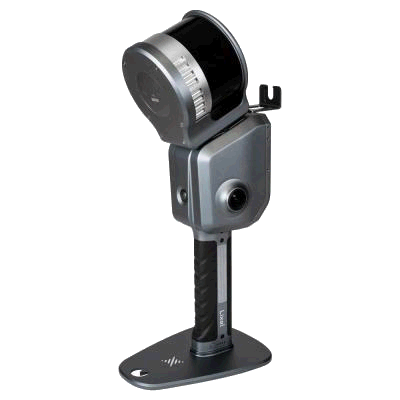
XGRIDS Lixel L2 PRO
Precision Redefined
The ultimate professional 3D scanning solution. Combining unmatched precision with real-time processing power, the XGRIDS L2 PRO sets the standard for demanding surveying and engineering projects.
Surveying redefined.
Industry-leading accuracy meets real-time SLAM processing. The Lixel L2 PRO is built for the most demanding professional workflows.
Unmatched Precision
Industry-leading accuracy for the most demanding surveying and engineering projects.
Real-Time Processing
Instant point cloud generation with real-time SLAM processing and visualisation.
360° Panoramic Camera
Full spherical imagery capture for complete visual documentation alongside point cloud data.
Rugged Design
Built to withstand harsh field conditions with IP54 protection rating.
Precision in every detail.
Built for every industry.
From deep underground mines to historic heritage sites, the L2 PRO delivers survey-grade data where traditional scanners can't reach.
Professional Surveying
High-accuracy topographic surveys, boundary surveys, and volume calculations for demanding projects.
Civil Engineering
Detailed site documentation, infrastructure inspection, and construction verification.
Mining & Quarrying
Stockpile measurements, underground mapping, and safety monitoring in challenging environments.
Industrial Facilities
Complex piping systems, plant documentation, and as-built verification for industrial projects.
Tunnels & Underground
Comprehensive tunnel surveys, utility corridor mapping, and underground space documentation.
Heritage Preservation
Detailed documentation of historic structures and archaeological sites with millimeter precision.
Engineered for excellence.
Seamless productivity.
Optimised for speed and reliability, the L2 PRO workflow takes you from site setup to final delivery in record time.
Setup
Quick calibration and configuration for optimal scanning parameters.
Capture
Real-time scanning with live preview and quality control monitoring.
Process
Advanced processing in LixelStudio with automated registration.
Deliver
Export to multiple formats for CAD, GIS, and BIM integration.
Trusted worldwide.
Join leading surveying and engineering firms worldwide who trust the L2 PRO for their most demanding projects.
Effective scanning range for large-scale projects
Survey-grade accuracy for precision work with RTK enabled
Industry standard data export
Add the Veesus Software Bundle for only £200
Bolt on the full Veesus software bundle to any scanner purchase for just £200 — get Arena4D, our CAD plugins and the tools you need to edit, share and visualise your scans from day one.
Accepted Payment Methods
All transactions are securely processed via Stripe